
Altun Ha Mayan Ruins
Altun Ha Mayan Ruins is the name given to the ruins of an ancient Mayan city in Belize, located in the Belize District about 50 kilometres (31 mi) north of Belize City and about 10 kilometres (6.2 mi) west of the shore of the Caribbean Sea. The site covers an area of about 8 square kilometres (3.1 sq mi).
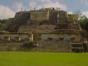
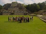
Stones from the ruins of the ancient structures were reused for residential construction of the agricultural village of Rockstone Pond in modern times, but the ancient site did not come to the attention of archeologists until 1963. The Old Northern Highway connects Altun Ha to Belize's Northern Highway, and the site is accessible for tourism. The largest of Altun Ha's temple-pyramids, the "Temple of the Masonry Altars", is 16 metres (52 ft) high. A drawing of this structure is the logo of Belize's leading brand of beer, "Belikin".
According to the Belize Institute of Archaeology, the site's name means "Rockstone Water," and is a Yucatec Mayan approximation of the name of the nearby village of Rockstone Pond. In Yucatec Mayan, haltun is a stone water deposit or cistern, and ha means water.[3] An ancient emblem glyph for the site has been identified, but its phonetic reading is not currently known.
In 1961, W.R. Bullard conducted excavations led by the Royal Ontario Museum, at Baking Pot and San Estevan, and although no excavations took place, the site was initially called “Rockstone Pond.” In 1963, quarrying activity by local villagers led to the recovery of a large, elaborately carved jade pendant. The current commissioner of archaeology, Hamilton Anderson, notified David M. Pendergast and a reconnaissance trip was made in 1963. Starting in 1964, an archaeological team led by Dr. David Pendergast of the Royal Ontario Museum began extensive excavations and restorations of the site, which continued through 1970. There was a total of 40 months of excavation with a field season in 1971 of ceramic and laboratory analysis.
Altun Ha Mayan Ruins lies on the north-central coastal plain of Belize, in a dry tropical zone. The site was very swampy during its pre-Columbian occupation, with very few recognizable water sources. Currently, the only recognizable natural water source is a creek beyond the northern limit of the mapped area. The water sources used during occupation were Gordon Pond, which is the main reservoir, and the Camp Aguada, which is located in the site center. The site may have contained two chultuns, but provenience is lost since they are used in modern times.
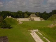
The site itself consists of a central precinct composed of Groups A and B. Groups A and B and Zones C, D, and E consist of the nucleated area, with Zones G, J, K, M, N making part of the suburban area. The site does not contain any stela, suggesting that stelae were not part of ceremonial procedures. There are two recorded causeways, one in Zone C and one connecting Zone E and Zone F. The Zone C causeway does not connect to any structures, but is probably related to Structure C13, and was perhaps used for ceremonial purposes. The other causeway connected the two zones where water sources were located, and was constructed for topographical reasons, specifically to traverse areas of swampy land; it may have been impassable without raised walkways.